The electrical resistivity survey is a geophysical technique that produces an image of the subsurface showing the distribution of electrical conductivity, down to depths of 100 meters. Fundamentally, dry rock has many orders of magnitude greater resistivity (lower conductivity) than rock that contains water. The greater the fracturing, the lower is the resistivity value of the rock.This technology has proven very reliable for mapping water-bearing fractures underground.
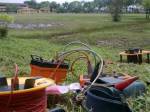
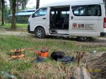
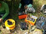
The geophysical survey is commonly carried out with a multi-electrode system, involves 25 – 100 electrodes laid out in a single line of 400m with a constant spacing. A computer-controlled system is then used to automatically select the active electrodes for each measurement. The survey was conducted using the pole-dipole protocol method. The data collected in the survey were then interpreted using a microcomputer.

Electrical Resistivity investigation offers highly applicable and useful aid in discovering groundwater resources. The Electrical Resistivity survey is used mainly to determine the subsoil lithology and to assess the potential of groundwater in the area being investigated. The investigation will also provide the best suitable drilling location and the probable depth at which groundwater is available.


Leave a comment